
The Utah Geographic Information Council Board is composed of volunteers from around the state of Utah who are passionate about geospatial data, topics, and applications. The Board is elected by those who are UGIC members as of the date of the current year’s annual UGIC conference (4 May 2026). Board members serve three year terms.
This year the three open seats are At-Large, Industry, and State. Members will vote for 1 candidate in each category.
Voting will open today Thursday, May 14th and close Wednesday, May 27th at 5:00 PM MDT. Results will be announced Friday May 29th.
At-Large

Ian Hazel
Bio:
I’ve worked on the staff/administrative side of the University of Utah in a GIS capacity for about 10 years, first as an intern while I was pursuing my undergraduate degree in Geography, then as an analyst upon graduating in 2019. I’ve overseen significant growth of my area in the last several years, and now manage a small team of GIS Specialists, primarily providing GIS needs to the auxiliary departments on campus.
In addition to overseeing departmental growth I’ve spearheaded multiple initiatives that have allowed our GIS data to provide meaningful insights to staff and senior leadership, including deep learning models tracking pavement quality assessment, demographic dashboards, and most recently an initiative to scale up indoor/outdoor asset tracking through drone imagery and LiDAR scanning.
Reason for Running:
The 2026 UGIC Conference in Kanab was my first major experience with the group, and it was inspiring to be around so many individuals from similar educational and professional backgrounds who were not only excited to share what they were working on, but were also highly interested in collaboration with their peers. Being able to serve on the board that invests so strongly in the current and future members of this community would be an absolute privilege. While I feel that the leadership and mentorship skills I’ve gained over the course of my career thus far would be an asset to the board, I’m mostly excited at the prospect of being able to learn and grow through my interactions with other board and community members as I serve in this position.
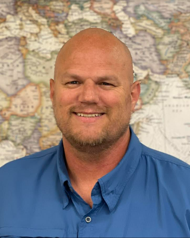
Jordan Merrell
Bio:
Jordan Merrell is the GIS Data Administrator for Uintah County and has been actively working in the GIS field for over 27 years. A UGIC member since 2000, he graduated from Utah State University with a bachelor’s degree in geography.
After a short stint at Tooele County GIS following graduation, Jordan was recruited by Uintah County during the 2000 UGIC conference in Moab to establish their GIS department, where he has served ever since.
When he is not streamlining operations for the County, Jordan enjoys outdoor adventures—hiking, fishing, and exploring natural hidden gems. He is always driven by curiosity, frequently asking, “Where does this go?” and “What does this do?”
Reason for Running:
To continue serving on the UGIC Board. This last year I have worked closely with and learned from Nick Kryger how to serve, work with, and help the vendors for the conference. I would like to continue in that capacity as the only one on the board trained to do so.

Mike Bova
Bio:
Mike Bova is a GIS Analyst with the Greater Salt Lake Municipal Services District, where he serves as a GIS liaison for the Engineering Department. His work focuses on CAD-to-GIS conversions, asset management, and supporting enterprise GIS initiatives across the organization. Mike also contributes to the MSD drone program, helping collect and manage data used by engineering, planning, marketing, and code enforcement teams.
Passionate about geospatial technology and the outdoors, Mike enjoys exploring Utah by foot, bike, and skis when he is away from the office.
Reason for Running:
I am honored to be nominated for the At-Large Member position on the Utah Geographic Information Council Board of Directors. I am excited for the opportunity to further engage with Utah’s GIS community and help advance the role of GIS throughout the state.
GIS plays a critical role across industries and public services, supporting better decision-making through spatial data and collaboration. I would value the opportunity to contribute to UGIC’s mission by supporting professional development, networking, and knowledge-sharing among GIS professionals at all levels. I also believe in promoting GIS education in schools and universities to help students explore careers and real-world applications in the geospatial field.
I believe my background in municipal GIS, engineering coordination, and emerging technologies such as UAS data collection would allow me to bring both practical experience and enthusiasm to the board.

Sarah Lawless
Bio:
Geography and GIS are kind of in my blood. Some of my earliest memories are helping my dad collect remote imagery of invasive knapweed out in Utah’s west desert, and that early exposure to maps, imagery, and the landscape around me eventually turned into a career. Today I’m the GIS Lead and a Senior Data Scientist at Wasatch Front Regional Council. I earned my GIS degree from Brigham Young University and later completed a Master’s in Business Analytics at Southern Utah University. Over the last 8+ years, I’ve worked in both consulting and regional government, which has given me the chance to work with all kinds of GIS data and projects. What I enjoy most is building online apps and finding ways to tell stories with data that actually connect with people and help them better understand the world around them.
That same love of geography is a big reason I’ve stayed involved with GIS Day at UVU for the past seven years, including two years helping coordinate the event. I especially love working with elementary school kids and finding creative ways to teach them about maps, data, and our world, especially through our GIS Galaxy Quest activity. UGIC, SLUG, and UVGIS has also become a huge part of my career and are some of my favorite communities to be part of. I look forward to reconnecting with all my GIS friends!
Reason for Running:
I’d love the opportunity to give back and help continue building that community for others. I enjoy bringing people together around maps and data, whether that’s through conferences, outreach events, web applications, or just sharing ideas and solving problems together. I think GIS is at its best when it helps people better understand and care for the world around them, both social and physical, and I’d love to help UGIC continue creating opportunities for learning, collaboration, and creativity across the state.

Tom Zumbado
Bio:
A true-blue civil servant, Tom has been a staple of the local government scene since 2012, serving many roles before landing his GIS Manager dream job with the Salt Lake City Corporation. Nowadays, he manages the GIS efforts of the Engineering division, including the oversight and coordination of the Division’s flagship drone program. He is a strong believer in the beauty and value of maps, having showcased many of his own pieces in professional galleries and publications. Prior to earning his M.S. in Geography from the U, Tom served his community and country as a Firefighter/EMT and U.S. Army Paratrooper. Whenever he’s not making real maps, he’s making pretend ones while playing Dungeons & Dragons with his family and friends.
Reason for Running:
My nomination for this election came as a surprise. And that means somewhere in Utah, I have a geographer colleague who believes I have something meaningful to contribute to our wonderful GIS community. The current and previous members of the UGIC Board always felt like the noblest ambassadors of our field: teachers, mentors, and technological sages who were identified and chosen by their peers to represent our awesome profession. Through their efforts and dedication, they lifted all of us. And now some of you think I can help lift us too? That’s good enough for me. So, if I’m elected, I promise to do my best to promote collaboration, share knowledge, build camaraderie, and continue the efforts made by previous UGIC board members that set the strong foundation we have today. This body of professionals is more than just a hub of technological know-how, it’s a sanctuary for everyone who’s ever looked at a map and been fascinated by what they saw. Because whether you’re a planner, surveyor, ecologist, analyst, consultant, UAS pilot, or field team member, we’re all geographers.
Industry

Adrian Sellars
Bio:
Adrian Sellars is a GIS Manager with HDR, an employee-owned AEC firm with more than 150 geospatial professionals. I was first introduced to GIS in 2006 while earning my bachelor’s degree in Environmental Planning and Management from SUNY Plattsburgh in upstate New York. I was immediately hooked and pursued every course and learning opportunity available.
Drawn west by Utah’s “champagne powder,” I joined UDOT, where I spent 10 years building a strong foundation in construction, environmental documentation, and GIS. During that time, I also earned my master’s degree in Geographic Information Science from the University of Utah.
Five years ago, I transitioned to HDR, where I’ve continued to expand my GIS expertise across multiple industries. My work focuses on pushing boundaries with GIS—whether through environmental impact statements, large-scale data transformation efforts, or improving field operations. I’m fortunate to collaborate with an exceptional team of professionals across the country on a wide range of impactful projects.
Outside of work, I enjoy spending time with my wife and two young children, snowboarding, mountain biking, and restoring our 100-year-old home.
Reason for running:
Over the past 10 years, I have benefited greatly from everything UGIC has to offer. From valuable learning opportunities to meaningful professional connections, UGIC has played an important role in my growth within the GIS community.
I’m running because I see this as an opportunity to give back and help strengthen the organization that has given me so much. I am passionate about fostering learning, building connections, and supporting the continued growth of the GIS community in Utah. I’m excited about the opportunity to contribute, bring fresh perspective, and help ensure UGIC continues to thrive for years to come.
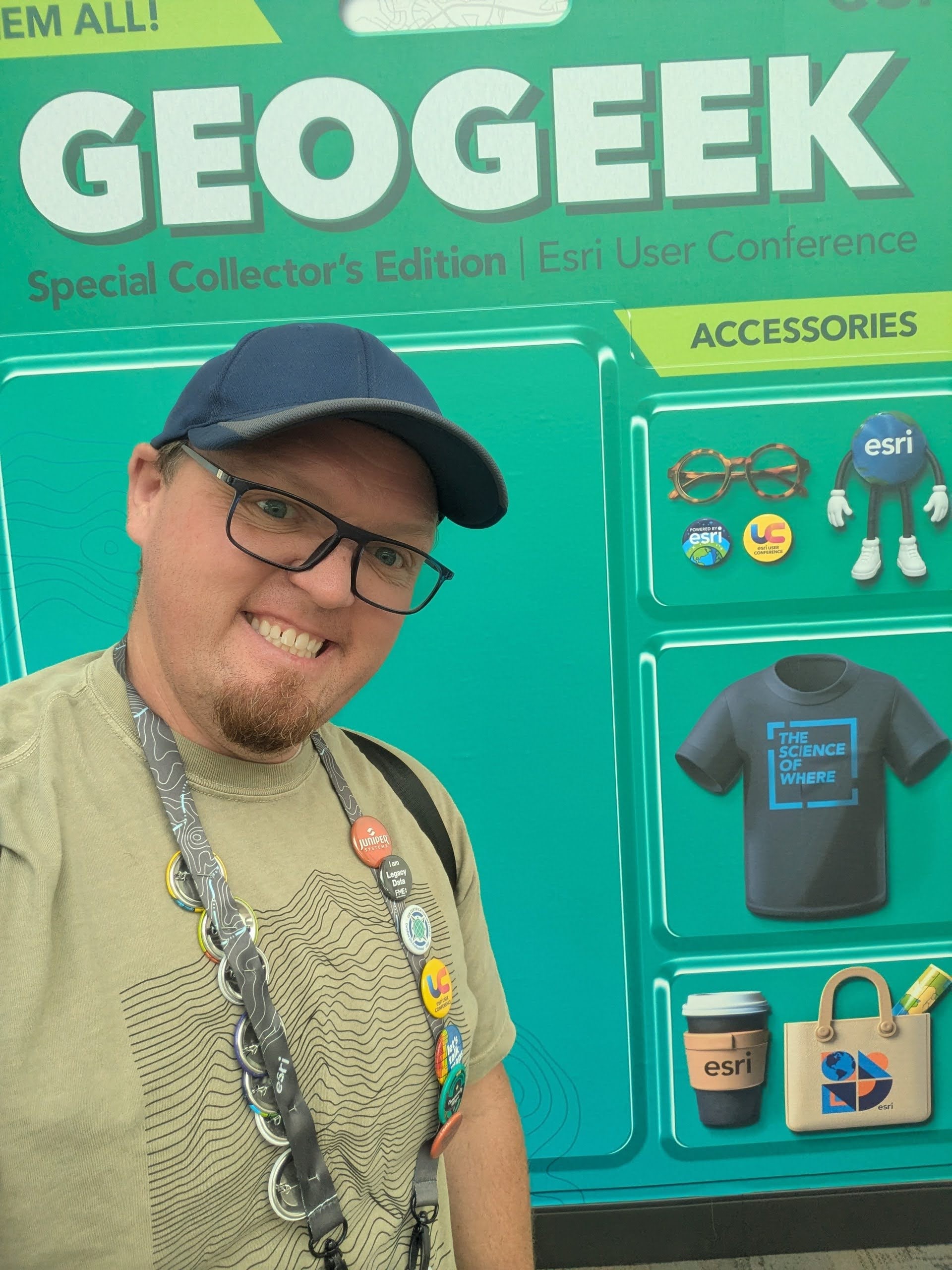
Adrian Welsh
Bio:
I have worked in GIS for more than 20 years across consulting, engineering, local government, and enterprise GIS administration, and I still genuinely enjoy helping people solve problems spatially. I currently work in the AEC industry supporting engineering and planning teams through enterprise GIS strategy, web mapping, dashboards, and spatial data management. Apparently, I also cannot resist building “just one more dashboard” when I probably should be doing something else.
UGIC has been a major part of my professional life for nearly 20 years, and I have attended almost every conference I could get to during that time. I have also served on the Salt Lake GIS Users Group (SLUG) board for about 10 years, helping organize community events and connect GIS professionals across Utah. Outside of GIS, I enjoy skiing, hiking, listening to audiobooks, coaching youth sports, and refereeing soccer games with my kids.
Reason for running:
I was genuinely honored to be nominated for the UGIC Board, especially since the nominations are anonymous, and I still do not know who decided this was a good idea. UGIC has played an important role in my career through the conferences, professional relationships, mentorship, and sense of community it creates within Utah GIS.
After many years of benefiting from the Utah GIS community through both UGIC and SLUG, I feel like serving on the board would be a meaningful opportunity to give back. I care deeply about helping people connect, share ideas, and continue building the collaborative and welcoming GIS community that makes Utah special, and I would be excited for the opportunity to contribute from the industry perspective.

Brock Saylor
Bio:
Brock is currently Langan’s Digital Solution Client Director, managing Langan’s Digital Solutions/GIS team in the western United States. Brock’s client focus is centered around resorts, K-12, higher education, healthcare, data centers, and local/state government service sectors. He has over 16 years of experience managing B2B sales, SaaS projects, partner management (Esri, OpenGov, AWS, Azure), client success, and designing, deploying, and managing enterprise scale geospatial solutions for a variety of industries and clients. He also manages the western team to provide a variety of services focused on operations and maintenance tracking, lifecycle management, safety, and security, asset and facility management, and smart utilities.
Reason for running:
I would like to meet more people in the Utah GIS community and get more involved with statewide GIS initiatives.
Christina McCullock
Bio:
Since joining Gateway Mapping in 2013, I have focused on transforming complex workflows into efficient, user-friendly processes. Collaboration with clients ranging from cities and special service districts to major transportation organizations is a big part of my job, and I love uncovering their unique challenges and delivering innovative GIS solutions.
As part of Gateway Mapping’s leadership team, I help foster an environment that supports both personal growth and company success.
On the weekends, you will likely find me exploring mountain trails, browsing my favorite bookstores, or playing games with my family.
Reason for running:
Over the years, I have discovered that there is a lot to be said for finding a community – people you share interests with, people to swap ideas with, people you can have fun with, a place you can belong. The Utah GIS community is one of those places for me, and I look forward every year to connecting with all of you from across the state.
Engaging with clients and colleagues from a wide range of disciplines has taught me the value of connections and relationships. Those connections are a huge part of what makes UGIC such an important organization. I welcome the opportunity to contribute my experience to the UGIC community by serving alongside the great people on the board.

Paul Kelley
Bio:
Howdy! I live in Cache Valley, Utah with my amazing wife and four awesome kids. I work as a Sales Executive for Farragut Systems and have been working in the GIS industry for over 10 years. I love everything about GIS and have always had a passion for maps, technology, and the way GIS helps organizations make better decisions and serve their communities.
Throughout my career, I have worked closely with utilities, telecom, and local government organizations, helping them improve workflows and better manage spatial data. One of the things I enjoy most about GIS is the collaboration and problem-solving that happens within the GIS community. I feel very fortunate to work in an industry filled with passionate and innovative people.
When I’m not playing with maps, I am usually in the mountains or on a river. I am a volunteer coach for our local NICA mountain bike team and love mountain biking with my family. I am excited for the opportunity to serve and contribute to the continued growth of the GIS community in Utah.
Reason for running:
I have been a part of and attended many GIS events and organizations over the years, but there is something special about UGIC. UGIC is by far one of the best organized, most welcoming, and most enjoyable organizations I have worked with. The community, collaboration, and passion for GIS within UGIC are truly unique.
I would love the opportunity to become more involved and help support the organization in any way I can. I am passionate about helping grow the GIS community in Utah, strengthening connections across industries, and encouraging more collaboration and knowledge sharing among members.
State

Emma Hollinger
Bio:
I have had the privilege of working for the State of Utah’s Division of Emergency Management (DEM) for the past 7 years in several roles, most recently and currently as a GIS analyst. As an analyst I create useful spatial tools for decision making before and after natural disasters. During disasters, I work in the State Emergency Operations Center, facilitating situational awareness using GIS tools. I am passionate about using GIS to help local communities recover from disasters and equipping damage assessors and recovery personnel with spatial tools for streamlined data collection. During my time at DEM, I received a Department of Public Safety Medal of Excellence in addition to a DEM Innovation Award for developing an incident reporting Survey123 tool. I am an alumnus of the University of Utah, holding a B.S. in Geography with an emphasis in hazards, in addition to a GIS certificate. This past spring semester I had the privilege of mentoring two UofU GIS capstone students who successfully completed a capstone project with our agency
Reason for running:
I am always looking for new ways to be involved and support our Utah GIS community! Although I am in the earlier years of my career, my “less-seasoned” perspective would be advantageous in supporting young professionals right out of college, helping them get plugged in, and making UGIC even more accessible. Serving on the board would allow me to mentor new professionals effectively, especially since I was in their position not long ago. I also have a knack for event planning and would love to help plan the UGIC conference to make it the best it can be!
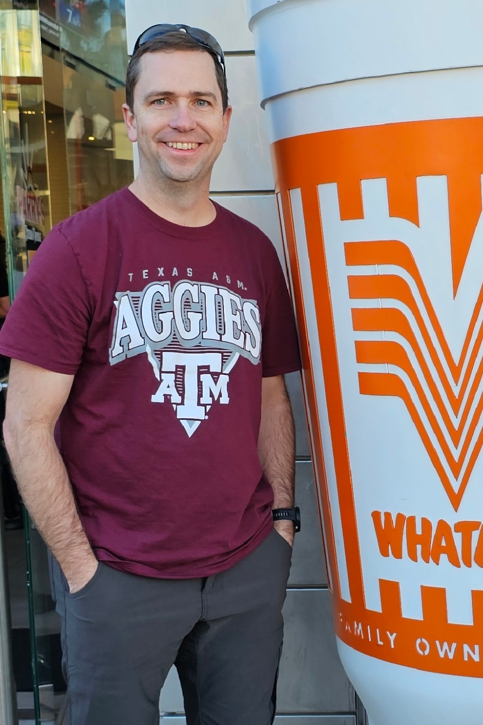
Kenneth Richards
Bio:
I am a GIS Analyst for the Utah Department of Transportation in Cedar City and an adjunct professor at SUU teaching GIS. I have been with UDOT for four and a half years and with Iron County GIS before that. I have been involved in the geospatial industry for 17 years, with experience in land surveying, local and state government and education. I love living in Southern Utah and enjoy any chance I get to take my family and me out to explore our great state.
Reason for running:
I love the geospatial community we have in Utah and I want to continue supporting it in any way I can. Serving on the UGIC Board is a great way to give back to the community and a great way to help future generations of GIS professionals.

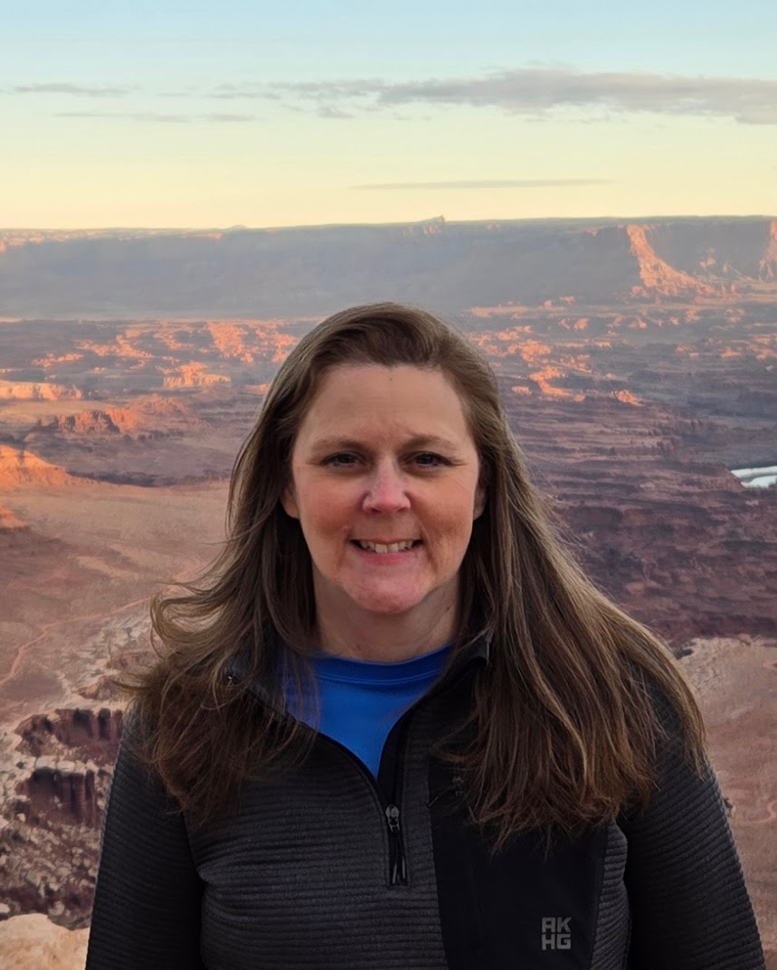
Sarah Lindsey
Bio:
Sarah Lindsey is a Utah native who loves using maps to explore the diversity and natural beauty of our state. Sarah works for the Utah Division of Wildlife Resources as a Senior GIS Analyst and as the Data Manager for the Utah Natural Heritage Program. Her work focuses on using geospatial technology to track the distribution of species of greatest conservation need, ensuring this crucial information reaches decision makers in order to protect threatened and endangered species, inform conservation actions, and sustain Utah’s wildlife biodiversity for years to come. Sarah also collaborates with the DNR’s Law Enforcement section using GIS applications to streamline investigation workflows and improve reporting processes for the public. Sarah works to integrate geospatial technology into these critical areas to ensure a more efficient and effective approach to safeguarding Utah’s natural resources.
Reason for running:
I have a passion for GIS and its potential to make a positive impact. I have personally benefited from the many opportunities for training and networking that UGIC provides, and I would love to give back to the GIS community by serving a second term on the UGIC board. I have experience working with GIS users from a variety of organizations as my work involves collaboration with federal and state agencies, local governments, law enforcement, private contractors, universities, students and non-profit organizations. I would be dedicated to supporting these communities in the advancement of geographic information science and technology use, as well as promoting geospatial education opportunities throughout Utah.